I think we're the last people to leave this hotel too. These people are all too busy. We head back up the road to review Kona. Actually, it's quite a long way back up the road but we spot a few tempting coffee shops on the way. Kona, meaning leeward, is what everyone seems to call everything on this side of the island, including the main town, Kailua.
There are, apparently, a few things to see and do but certainly the road along the shore could have you in any number of sea shore towns with shops, restaurants, hotels, etc.. Pretty forgettable. Following the shoreline along we ended up at a dead end at the back of a golf course where the roadside sprinklers were giving some birds a free bath. As it happened this was the spot where the old Hawaiian religion `died.' A euphemism for the loyal followers of the traditional faiths being bloodily massacred before, by pure chance, Christian missionaries arrived on the same spot a few months later.
The next stop was Puuhonua o Honainau, a place of refuge (a sanctuary for those who broke the rules; usual sentence death [unless you scarpered to the refuge]). I wasn't listening to Helen's poor pronounciation and she didn't notice the park soon enough so we shot past. Just beyond the road becomes a narrow single lane with deep rock drop offs on either side. Having time to spare we had no worries but noted the car behind hesitantly follow, clearly another tourist [tailgating]. The unfortunate thing is (for them) that the road is dead straight and four miles long.
At the far end is Kealakekua Bay where we stopped to not see any Spinner Dolphins but did identify the monument on the far side at the spot shere Captain Cook died. His bones may well lie in some of the caves high above reserved for royal burials. We didn't stay for long at the place of refuge as they wanted US$5 and we're too poor (or something). We stopped at Kona Mountain Coffee for lunch and a nice tempting to purchase coffee. [Hmm, not sure what I meant there.]
Looking for somewhere to stop to extract chocolate from the boot we turned into an unmarked side road where we discovered an array of roads not marked on any of our maps. Presumably residential in an American way these roads stretched for miles up and down hills [in a strict grid-iron] with the occaisional house dotted in amongst the lava rocks.
Back on the highway we turned south down South Point Road looking for the southernmost point in the USA. There's a shipping beacon and some cliff to boat winches but little else to signal the profundity of location. Stood out on the shoreline it wasn't clear if the adjacent promontary was more southerly or not. Maybe it's down to the most southerly non regularly drenched by waves bit, I don't know. We did see a small pod of excited dolphins spin out of the waves on their way past enjoying the blusterly conditions tremendously. That could be down to the confluence of the Pacific at this point which creates good fishing conditions.
Most southerly point in the USA N18.91113 W155.68112 Elev. 20m!
Just round the corner is Green Sands Beach. Actually it's a three mile trek according to the uninterested youth manning the information centre. Fortunately green sand is in abundance, though not obvious. Caused by an excess of olivine in the local area the sand particles are a dark green colour. In practice [from any distance other than close up] they look like sand in shadow especially as they are generally mixed with the yellow stuff and are blown all about. A surprisingly good source is the car park though you'd only realise that when you've seen it on the beach.
April 1868 had `Devastation Day.' In Kau, after 5 days of earthquakes, lava erupted engulfing people and homes before tsunamis washed away what was left. There's a viewpoint over black lava and nothing else.
Welcome back!
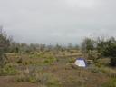
said the ranger when we produced our Volcanoes National Park ticket, which was nice. Our objective was the Kulanaokuaiki Camp ground, fortunately below the ever present rain at the crater rim. The campsite is basic, there's a long drop (`pit' in American) toilet, three gravel beds for tents [with picnic table] and that's it. No water, showers etc. etc.. And we're alone which perturbs Helen. We assess the campsite and select our pitch before assembling our rather frail looking tent.
We head into town unsure if we have to have a permit (`backcountry campers' do) or indeed if the tent will be there in a couple of hours either avoiding strong winds or theft. Buying emergency provisions: water and swiss rolls, I notice they have an LCD display for the legal age to buy cigarettes. Like a millenium countdown clock it shows the date for 18 years less one day ago. Gotta get those ciggies.
The local Thai restaurant is authentic with its Buffy looky-likey soundy-exactly-likey waitress in a pseudo-Thai getup and large pudding bowl portions of bland fried rice. Still, we don't want to be running to the toilet in the middle of the night. I have yet another micro-brewery beer that doesn't travel well. The important thing, though, is that we parked outside the laundrette. We badly need to wash some clothes.
We head back and to our surprise the tent is still standing and to Helen's relief there's another car and tent at the site. We settle in, and for the lack of light, despite the astonishingly good night sky, go to bed at 8:30. Fearful of every crunch of gravel and because I'm very hot I stay awake for about an hour before falling asleep, waking for an earth tremor, sleeping, waking for a third group to arrive, crash about and go to bed around midnight, then finally lumpy sleep.
Kulanaokuaiki Camp, Volcanoes National Park, Big Island N19.34411 W155.27383 Elev. 988m
Copyright 2003 Ian Fitchet. All rights reserved.