A slow start to the day, on the road at 10. But what a day when we finally look out. Picture perfect clear blue sky. Literally not a cloud to be seen. Today is Aoraki (Mt. Cook) the highest peak in NZ day. The landscape in this part of the world is pretty plain, rolling softly moulded hills with no vegetation or landmarks only dry grass. There's not much en route but we stop in Twizel, like a number of NZ towns, 300m off the main road. It's a skiing and adventure town so has a number of shops and cafes and helicopter rides but little else.
As we approach Lake Pukaki at the foot of Mt. Cook we spy a number of brilliant blue rivers and canals. Surely the work of the sun [a trick of the light]. There's a marked viewing spot at the end of the lake which lets you see Aoraki across the full length of the lake so we head for that first. We cross a wide canal of turquoise/sky blue water -- that's odd -- before turning the corner and, wow! The entire 40km lake is a stunning turquoise and at its head, standing almost alone is Aoraki (which makes it easy to spot!). An outstanding picture which is frankly a bit unreal. 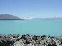
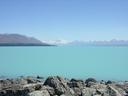
 Later reading suggests that the water colour is due to suspended rock particles reflecting sunlight which is a little odd as all the mountain run-off we've seen has been either crystal clear or battleship grey.
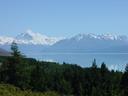
We head up the lakeside road the 55km to the town of Aoraki/Mt. Cook (there seems to be a bi-lingual problem with many place and object names in NZ) at the foot. Confirming my thoughts, two-thirds of the way up a grey river instantly turns into an even-richer-at-this-end turquoise lake. Just how odd is that?
The town of Aoraki/Mt. Cook has the Hermitage, a world famous hotel, a number of other motels, hostels, a few private dwellings and a hard-to-find visitor's centre. The (now side) view of Aoraki is slightly obscured so we take the track to Kea Point where we might get a better view. An hour's trudge up a gravel track later and Kea Point ("the last thing you'll see are Kea") offers views over the Hooker and Mueller galciers. Well it would do but for the enormous furrow gouged out by the Mueller galcier on our left. In times gone by [the Mueller galcier] has left a massive wall of moraine in front of us [the furrow] blocking any view of the Hooker valley below Aoraki. The Mueller glacier is now a shadow of its former self and today's sunshine isn't helping. As we take a leisurely look at Aoraki (we're knackered and need a rest) we hear plenty of thunderous cracking and crashing sounds. By chance when we look up we see huge chuks of the Mueller glacier, now reduced to halfway up Mt. Sefton, fall off and shatter down the mountain. By huge I mean not much visually but if you were there it'd be about several houses worth of ice just fell off, given for how long the ice and water flowed further down the mountain. Then another huge chunk (scale is a bit optimisitic here) maybe 100m x 50m x10m fell off right on camera. Lots of cooing by the attendent tourists. Still, you can't spend all day watching galciers lose tens of years of creation and we headed off towards Timaru, our base for the next two nights (mostly because everywhere else is full).
We stop at Lake Tekapo which is meant to have the same turquoisyness, which isn't true. That's either a guide book mistake or the boating activities allowed on this lake dispel it. I can't guess which. The town boasts two map attractions: a historic church and a monument. The historic church looks as though it was rebuilt recently and has a plate glass window overlooking the lake rather than the usual stained glass affair. Don't want the parishioners getting bored do we? The monument is of a collie and dedicated to those canine heroes who've served the area so well. What? Still, we were kept amused by some witless idiot who'd set his camera and tripod up opposite the church and was constantly frustrated by the unending stream of tourists [ruining the shot]. I was amused at the monument when the father of a family of seven which emerged from a camper van (presumably all five kids would catapault from the back through the windscreen in an accident) making determined attempts to stop his miscreant charges from swarming all over the bronze collie because people wanted to take pictures. Actually, no mate, I'm really stood here wondering what the fuss is about. Next stop was the Dog Kennel Corner. Some chasing about unearthed a plaque on a stone in the copse on the corner of the main road dedicated to a dog, kennelled on this spot years ago to keep the sheep in stock before the fence was built. What?
Last on our list of attractions was the Cleland zip-zag. We drive up a windy road called Cleland Rd to the top where, um, that was it. Maybe that's an attraction round here. It certainly had a few burnt rubber trails which suggests it was popular with the local sport vehicle enthusiasts.
The Anchor Motel in Timaru, home to YHA's Timaru Backpackers, has given us a self contained motel unit for a bargainous NZ$ 55.
We take a wander through Timaru which seems a busy enough place. It must be said that the South Island has had fewer one street towns than the North Island, perhaps due to a concentration of fewer people (three times as many live on the North Island which presumably lets them spread a little).
The Anchor Motel, Timaru S44.38750 E171.24127 Elev. -57m!!
Copyright 2002 Ian Fitchet. All rights reserved.