It rained in the night, only for five minutes or so but that was enough to demonstrate that the walls seemed quite waterproof but the groundsheet seemed to suck water in. Maybe that's why they suggested another groundsheet in the instructions. Some Americans talk loudly about burritos at six in the morning and it's no surprise that we're last up and in the campsite at nine.
We're going to `do' the Chain of Craters Road today, the twenty mile detour from Kilauea caldera down to as near as the road gets to lava -- which is pretty close as the lava regularly overruns it causing the parks people to move their hut back. We start right at the bottom following my nose for an unmarked attraction which turns out to be `Hazardous Area, Unstable Cliffs.' Ah well.
There are several stops on the way back up the escarpment (caused by the land being, um, too heavy and simply sinking several hundred feet at a fault line) giving views of the scale of some of the previous eruptions. Black lava pours over the cliffs spreading out in the plain below it on its way to the sea. You can see the old Chain of Craters Road from one viewpoint. That particular flow (in 1969) buried the land in up to 100m of lava. There's a couple of unmolested 10m stretches [of road] so, again, if you'd parked your car right...
The upper part of the road starts with Moana Ulu (the growing mountain) formed in the early 70s by a five year flow, it's a small shield volcano allegedy quiet but still steaming in a don't turn your back fashion. There's a pleasant walk through some lava trees, rather the remains of lava that stacked up around a resisting tree then cooled leaving, today, a nice tree shaped hole in a sticky up bit of lava maybe six feet high. You end up on the edge of a cinder cone, Puu Huluhulu, where you get a good view over the surrounds. In principle you can see Pu'u O'o, the current active vent but not today.
We see some Nene, the Hawaiian State Bird (a goose) which isn't so commonly seen and get some lowdown on walks from a retired travel guide from South California. The remainder of Chain of Craters Road is actually the craters from previous eruptions which vary in magnitude, the smallest 100m across and 20m deep, the largest 1km across (maybe) and 600m deep. It's hard to scale them, the trees look small by comparison. Most have a lava cap that looks like the boiling lava was suddenly frozen mid-swell as the pressure in the vent dropped. From most it's hard to tell where the lava went. Maybe the eruption just blew big holes in the ground.
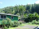
It's late afternoon and time we made progress towards some accomodation. We catch last orders at the Lava Rock Cafe -- it's a week since we were here first when we were the only customers, today we wait for a free table. We stock up with provisions (beer) and head off for the Shirakawa Motel again. It's a long drive but cheap and cheerful and we can get a shower which is quite necessary. We're the only people in, it seems, and it looks like only one other guest has signed in since we were last here.
We pop into the next town for some nosh at the (only) restaurant which is reasonable but is putting pressure on our stomachs unused to sensible eating. We decline to tip the live performer because we haven't got any money and he was just practicing some difficult Clapton on us, the only customers.
Shirakawa Motel, Waiohino, Big Island N19.06691 W155.60954 Elev. 327m
Copyright 2003 Ian Fitchet. All rights reserved.